To walk among the sand dunes at Findhorn is to walk in the footsteps of a Mesolithic hunter–gatherer, a Neolithic farmer with axe in hand, a Bronze Age herds-woman, perhaps an Iron Age child, and a soldier training for the D-day landing. This is not immediately obvious, since so little of the material culture of our predecessors survives. And the further back we go, the less there is. But the evidence is there if we look closely enough.
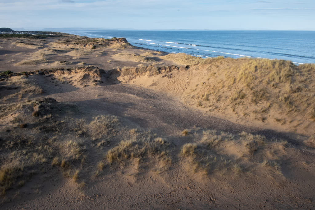
The main dunes site (FDS) near the back shore, east of Findhorn village.
I began to take a interest in the local archaeology back in 2002 or so, when during a conversation about local history and archaeology, Johnny Bichan, of Cullerne Farm, mentioned to me that he knew of a site in the dunes east of Findhorn Village where people had found flint in the past. I decided to go and have a look, and before long was finding not only flint tools and debitage—the waste material created during their manufacture—but also pot sherds, beads, copper alloy objects, burnt bone, and the remains of a midden, which contained sea shells and animal bone. Perhaps the star finds were the fragments of turquoise faience beads, a material long associated with Egypt. Analysis of similar beads found in Findhorn village and on Culbin Sands suggests that they may have been made locally. It’s now clear that at least one Bronze Age cremation burial took place here. One explanation for this may be that the site is in a liminal place—at a boundary between worlds: land and water; this world and the next. What we assume to be ritual deposits into water were common in the Bronze Age. This may be why it was used as a place for burial at that time.
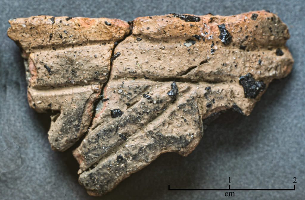
A sherd of decorated pot—probably a Bronze Age beaker.
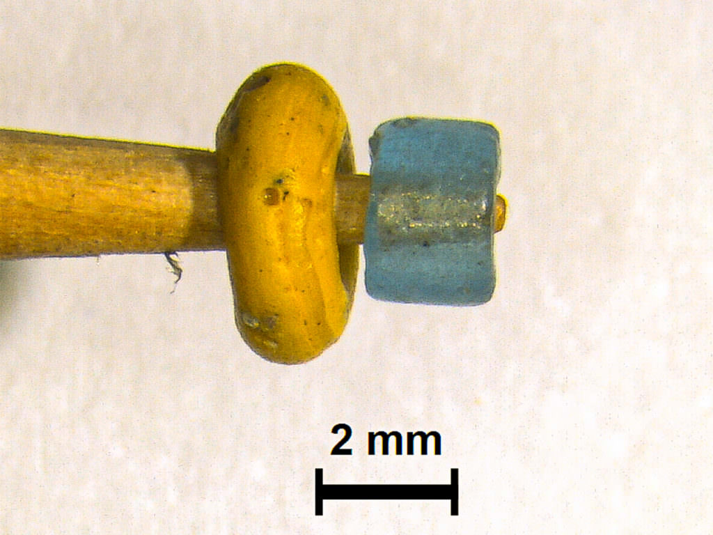
Two Iron Age beads found at the main dunes site (FDS): photo Alison Sheridan.
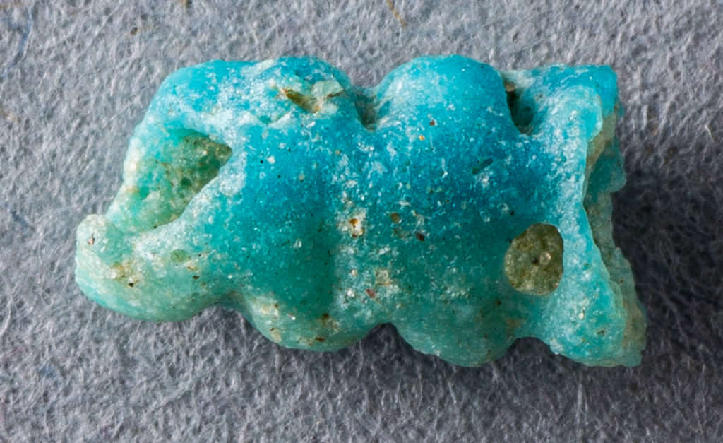
A 2 cm fragment of faience bead found At the main dunes site (FDS) and probably included in a Bronze Age cremation burial. Numerous similar beads were found in another burial uncovered in Findhorn Village.
In the years since I have made numerous visits to the site and over time accumulated objects from multiple periods ranging from the Mesolithic to the second world war. In that time I also made the transition from interested amateur, to archaeology student, to full-time professional field archaeologist. Even though my work takes me far and wide in the UK, I continue to explore the dunes for new archaeology.
The above-mentioned dunes site (FDS for short) that I have been investigating is very close to the shore and a few hundred metres east of the Dunes Road. Here there is a very extensive spread of fire-cracked stone and, until I picked them up, the objects mentioned above. It seems it was first used by hunter gatherers, likely between 7,000 and 9,000 before present (BP), at least as a temporary camp while harvesting local resources, and would have been one of many such sites along the coast, many of which have been lost to coastal erosion. We have lost 45 metres of coastline in the region of the Findhorn beach huts since the last war alone. These sites were predominantly piles of seashells, but sometimes also contained animal bone. Fire-cracked-stones tell us that they were building fires and probably cooking food. As with the main site on the Findhorn back shore, these middens sometimes include material from later periods, such as the Neolithic (5,500– 4,300 BP), the Bronze Age (4,300–3,000 BP) and Iron Age (3,000–1,550 BP).
Another similar site, but seemingly only containing fire-cracked-stone and a few Mesolithic flints and worked quartz, is located just north of Wilkie Woods. If you keep your eyes peeled while walking among the dunes, you can spot the fire-cracked-stone almost everywhere, though typically in small quantities, and widely scattered. I have yet to find a definite explanation for this. The main contender is a tidal wave sweeping through and scattering the remains of prehistoric hearths and camp sites. One such wave is known to have swept across the North Sea from Norway about 8,200 years ago, and is known as the Storegga tsunami. Mesolithic hunter gatherers are known to have been inhabiting the area at this time, and occupation deposits overlain by sediment from the tsunami have been excavated in Inverness and elsewhere in Scotland. It’s generally thought that this event also had the effect of finally cutting Britain off from mainland Europe, by permanently inundating the area known as Doggerland, off the east coast of England.
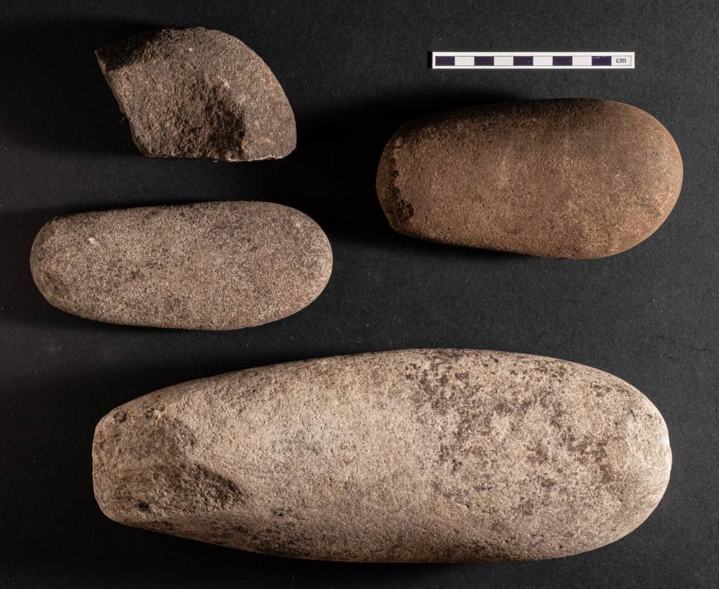
Hammer stone and a fragment of a mortar from the Cullerne midden site.
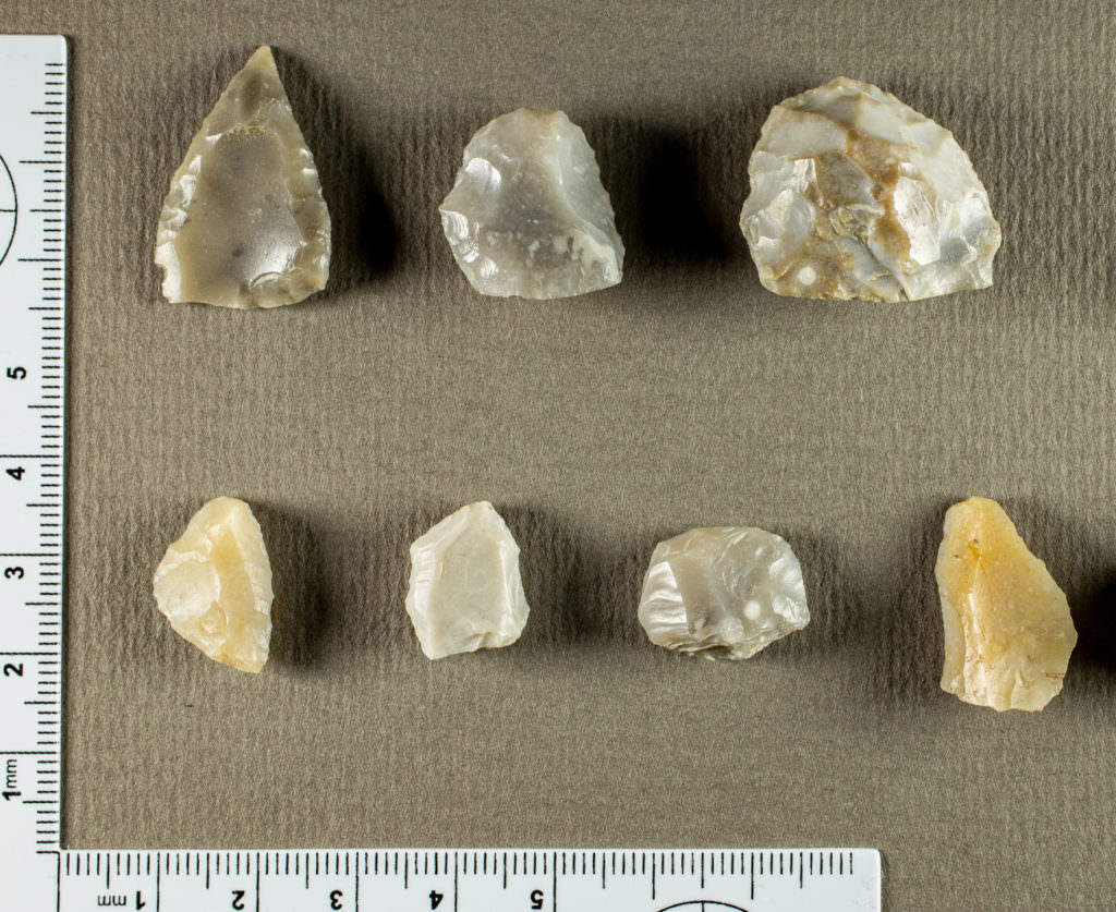
Flint tools found at the main dunes site (FDS).

A neolithic axe found 150m north of Wilkie Woods.
Evidence of occupation of the Findhorn area by the first farmers to arrive from the continent in the Neolithic only appeared recently when I learned from a specialist that the grey coloured flint found at the FDS site was likely brought here by these early farmers all the way from Yorkshire. More evidence came in May of this year when I found a small Neolithic axe on the surface about one hundred and fifty metres north of Wilkie Woods. The vegetation may have been quite different back then, and perhaps the farmer was looking for a particular type of wood. It’s possible that there were still remnants of woodlands containing elm and lime, among other tree species, which would later largely disappear from Scotland due to changes in the climate. Pollen from both of these species has been found as far north as Caithness and Orkney, but from thousands of years ago.
Early in 2020, during the COVID lockdown, I came across another midden deposit, this time on Cullerne Farm, in a spot where sand and pebbles were being extracted. It contained fire-cracked-stone, charred wood, shells, animal bone, and hammer stones. There was also what appears to have been a carefully deposited collection of items in a small hollow at the very edge of the midden: these included a 32 cm hammer stone lying on top of a red deer antler, with a sheep or goat mandible and six cattle molars nearby. We know that Bronze Age farmers were not just growing barley and wheat, but also depended heavily on livestock for food and clothing. This deposit at the edge of the midden is a good example of how their beliefs were bound up in and expressed through ritual actions involving the animals in their care. Ed Bichan generously paid for a radiocarbon date, which told us that the red deer died somewhere between 3,200 and 3,000 years ago, placing it towards the end of the Bronze Age. Further excavations early in 2023 revealed several shallow pits and a large post hole containing a deliberately broken granite saddle quern, which would have been used to grind grain into flour. Excitingly, the post hole is likely part of a round house of Bronze Age date just next to the midden, and is yet to be completely uncovered.
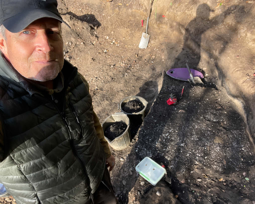
Well it seems that middens are the gift that keeps on giving. In October of 2023 Jonathan Caddy informed me that a shell midden had been spotted on the site of the main sanctuary at the Park, where groundworks had commenced for the new structure. This was an opportunity to excavate what was probably a largely undisturbed Mesolithic midden. The deposit lies just next to a raised beach, or former shoreline, from a time when the sea level was several metres higher, and Findhorn Bay extended up through the lower caravan site, Field of Dreams, and on into Cullerne Farm. The midden contains two distinct deposits separated by a layer of blown sand. The lower deposit is dominated by cockles, while the upper one is mostly mussels. I was able to excavate the midden over five days, and kept several large samples which I will examine in detail, and may contain some of the microliths—fine flint blades—that were made and used by Mesolithic hunter gatherers. I also managed to collect some charred wood from both deposits which will allow dating of the site.
Although so much of the evidence of our predecessors on the land is now lost to us, it is there to be found. And I for one plan to keep on looking.
Michael Sharpe
Community Friend and Professional Archaeologist
18/10/23. (All photos by Michael Sharpe, unless otherwise noted)